written by Trevor Wallace Nutrient Management Specialist at Alberta Agriculture and Forestry
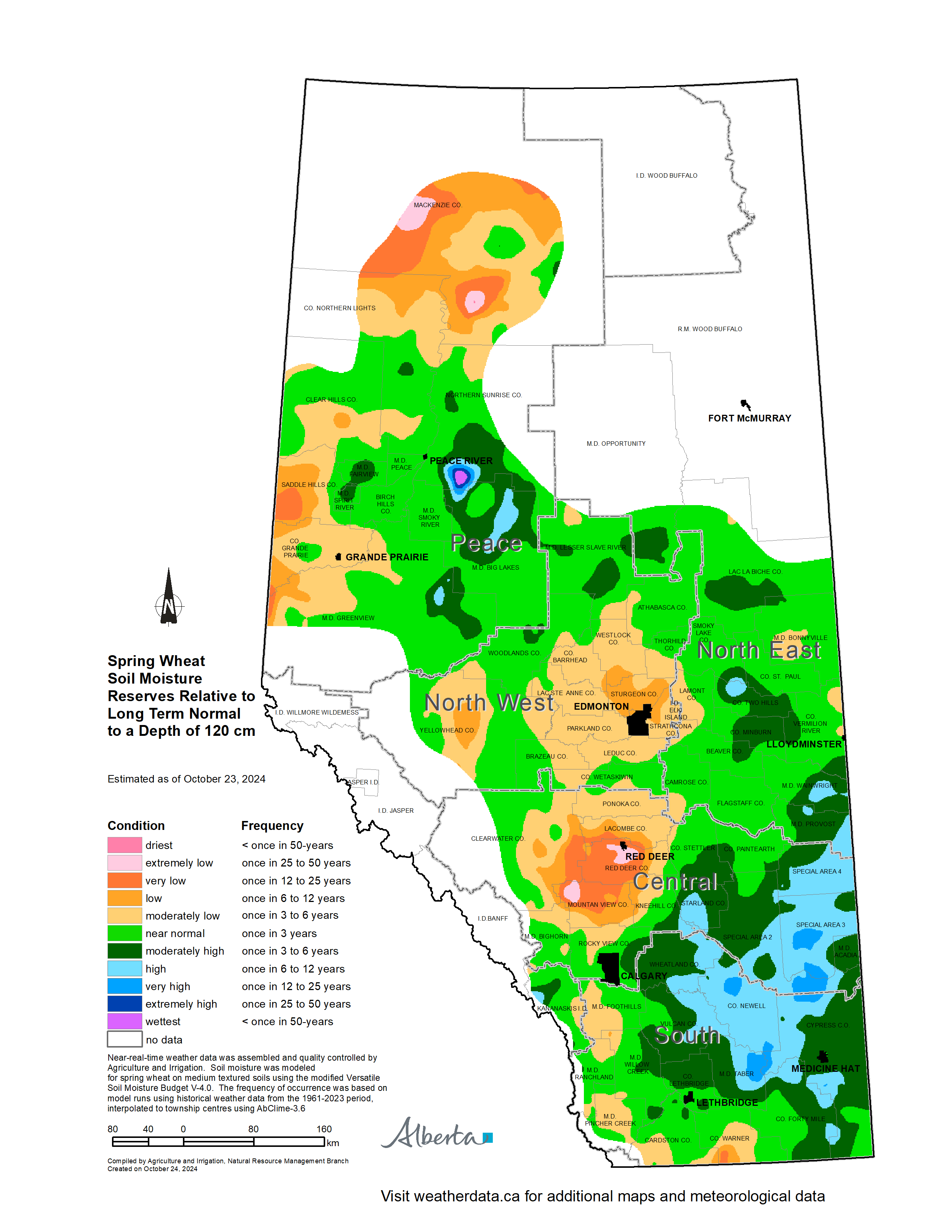
In Oct 2024, the estimated soil moisture reserves for approximately 65% of the province tended to
be near to above normal for that time of the year. Large parts of the eastern portions of the
Central and Southern Regions were estimated to be above normal. (Map 1). However, throughout much
of the North West Region, western portions of the Central Region and the western and northern
portions of the Peace Region soil moisture reserves ranged from once in 3 to once in 12-year lows.
Soil moisture in a large area south and east of Red Deer is trending toward a once in 25-year lows.
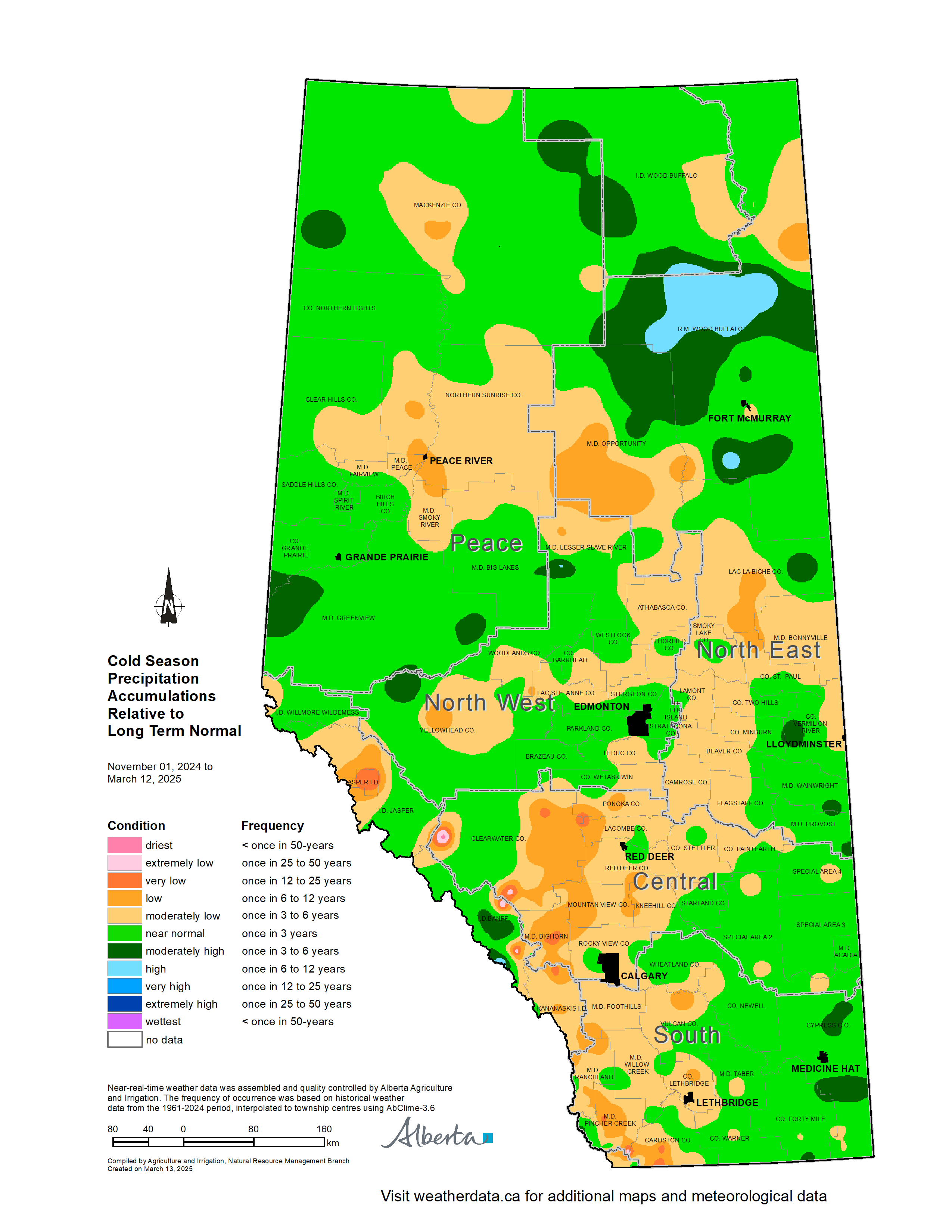
The winter or cold season, from November through March, is usually the driest time of the year in
Alberta. The cold season precipitation accumulation (Map 2), to date, is near normal across much of
the east half of the province, north and east of Edmonton and north into the Peace. A large area
running west of Lethbridge, north to Edmonton, then east to Lac La Biche County as well as around
Peace River and High Level continue to report moderately low (once in 3 to 6-year lows), and low
(once in 6 to 12-year lows) moisture accumulations relative to normal.
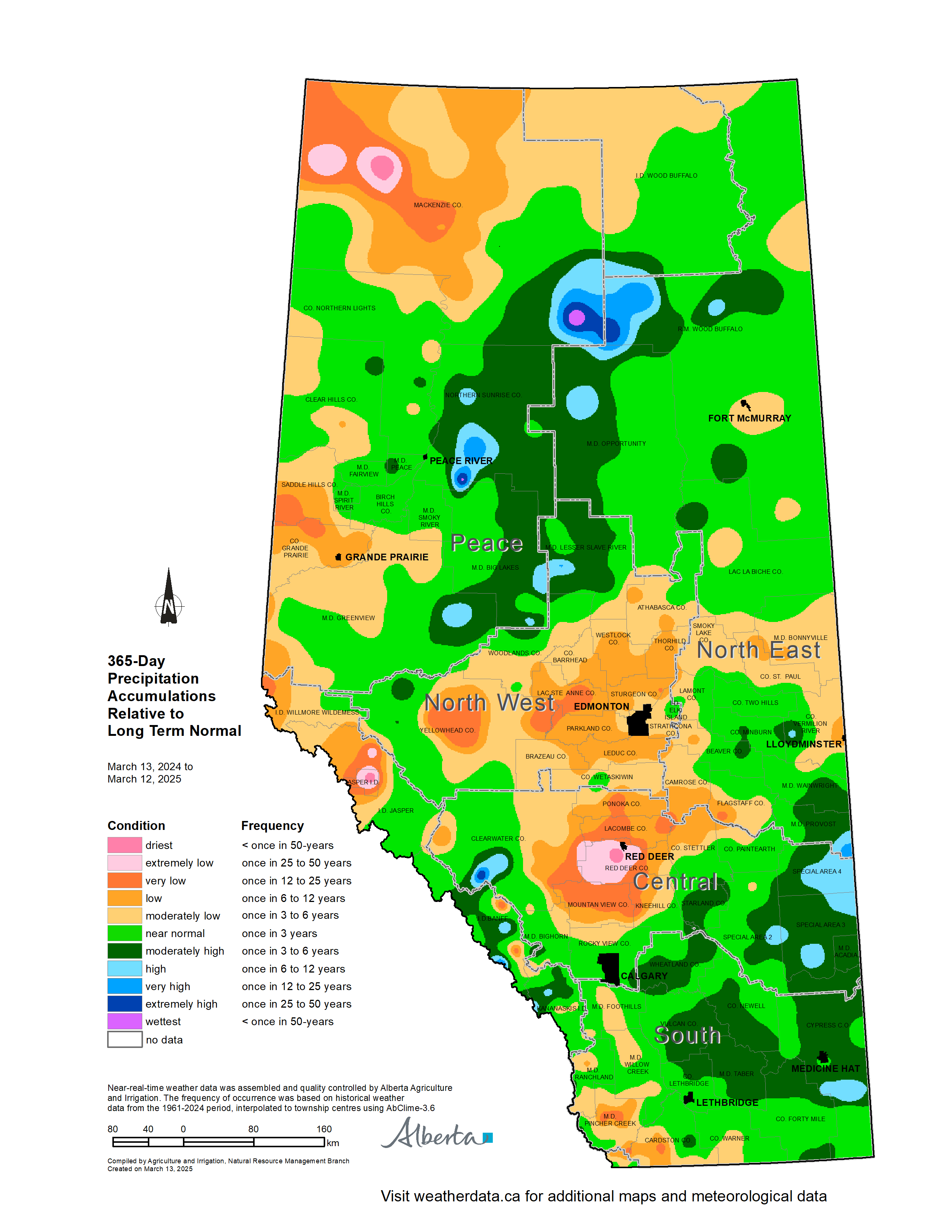
Looking back over the past 365 days, precipitation accumulations continue to remain below normal
across a large area from Mountain View County, north to Yellowhead County and then extending
east to the Saskatchewan border (Map 3). Similar below normal conditions are being recorded through
much of the Northern Peace Region and around Grand Prairie. Once in 25-year lows continue to
persist in areas in and around Red Deer. Once in 6 to 12-year lows extend around Red Deer,
northeast of Edmonton, around and west of Grande Prairie, as well as north in the Peace
Region to the border with the Northwest Territories. This area is reporting, relative to average,
year- over-year precipitation accumulations 70 to 90% of normal (average) with some areas only
receiving 50 to 70% of annual average precipitation.
Conversely, land south and east of a line between Calgary and Lloydminster, extending all the way
down to the US border and east to the Saskatchewan border, are reporting moderately higher than
normal precipitation accumulations. Here, some areas are reporting accumulations of 110 to 130% of
normal (average) along with some relatively small pockets reporting accumulations of 130 to 150% of
normal, which is positive news for those farming in these areas.
The normal precipitation for the agricultural area running east of the Highway 2 corridor from
Bonnyville south to the Saskatchewan border over this time frame, averages 10 to 15 mm. Normal
precipitation levels increase as you move north and east of this region to 15 to 20 mm and
continues to increase to 20 to 25 mm across the Peace Region.
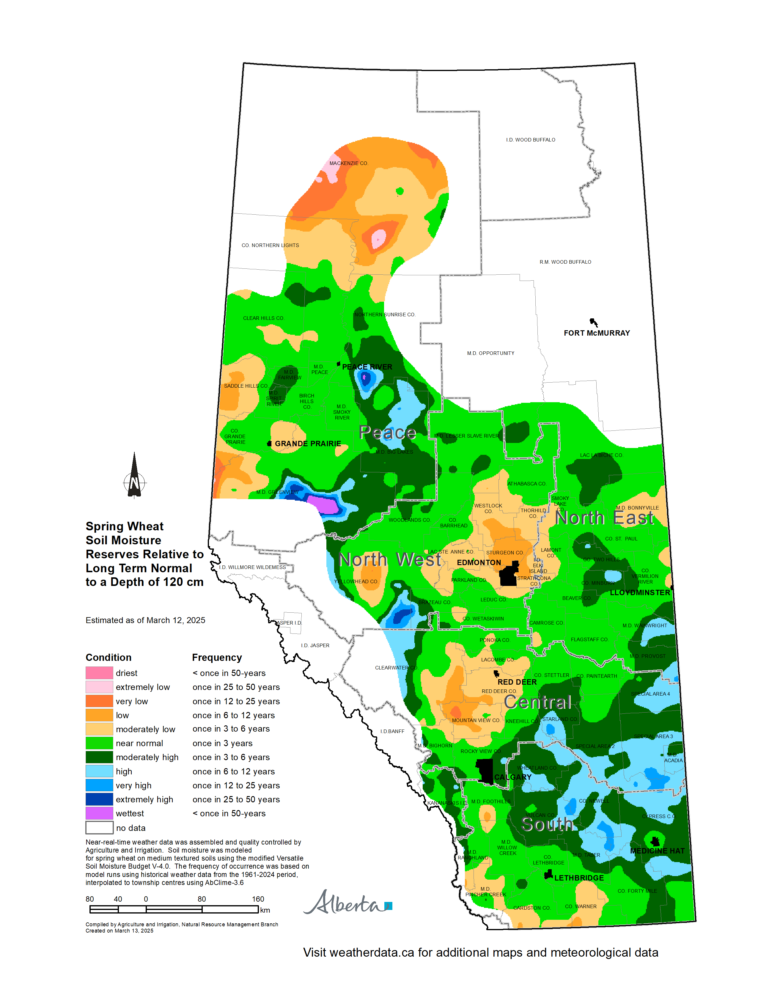
The estimated spring wheat soil moisture reserves relative to long term normal for much of the
province appear to be near normal (once in 3-years) or moderately high (once in 3 to 6 years) (Map
4). With some areas estimated to have high (one in 6 to 12-years) moisture reserves. There is a
very high probability that this area will be returning to normal spring moisture conditions in May.
The area around Red Deer and south through Mountainview, around Edmonton, east of Grand Prairie and
North of Manning to the border with the Northwest Territories are estimated to have moderately low
(one in 3 to 6 year, low (once in 6 to 12 year) and a few pockets of very low (once in 12 to 25
year) soil moisture reserves. The probability, if current precipitation trends remain below
normal, of these areas returning to normal spring moisture conditions is 40-50%.
It is important to emphasize that the cold season, on average, is the driest time of the year. Being the relative dry season, even above average moisture at this time of year is typically not enough to make a significant impact on “year-to-date” moisture deficits, nor would they usually be sufficient to create excess moisture conditions. For agriculture, May, June and July remain the most important months for receiving precipitation. The 2025 cropping season is only a few months away. We are beginning to move into what has traditionally been Alberta’s wetter period; there is ample time to receive adequate moisture.
The Alberta Climate Information Service (ACIS) is an on-line tool and mobile friendly web application that provides climate data for the province of Alberta. Weather data is collected from over 500 near real time hourly reporting stations. Data available from ACIS is quality controlled and reliable. While the specific elements collected at each station will vary slightly in general information on precipitation, temperature, wind speed and direction are collected. Other elements such as soil moisture, soil temperature, depth of snowpack, growing degree days, corn and potato heat units, frost probability, fine fuel moisture content and initial spread index are calculated or modeled for stations and townships across the province.
ACIS provides several weather information tools in one location including current weather conditions (in near real time), weather forecasts, radar imagery, climate and atlas maps, climate normal, and historical weather data. ACIS offers a variety of decision support tools based on the data collected such as: fusarium infection risk assessment tools and insect pest prediction.
A user can view climate data in your selected areas by choosing from the weather stations near a desired location. The service has the ability to display information from multiple stations at once in one convenient view using the weather station data viewer. Maps are published weekly to help producers, agronomist, consultants, planners, government and non-government organizations make decisions. Bookmark ACIS and visit it to help inform your farm and crop management decisions. https://www.acis.alberta.ca/.